In the 2018 report for Skibbereen in the National Tidy Towns competition the Adjudicator made the following comment under the category Approach Roads, Streets & Lanes / Bóithre Isteach, Sráideanna & Lánaí:
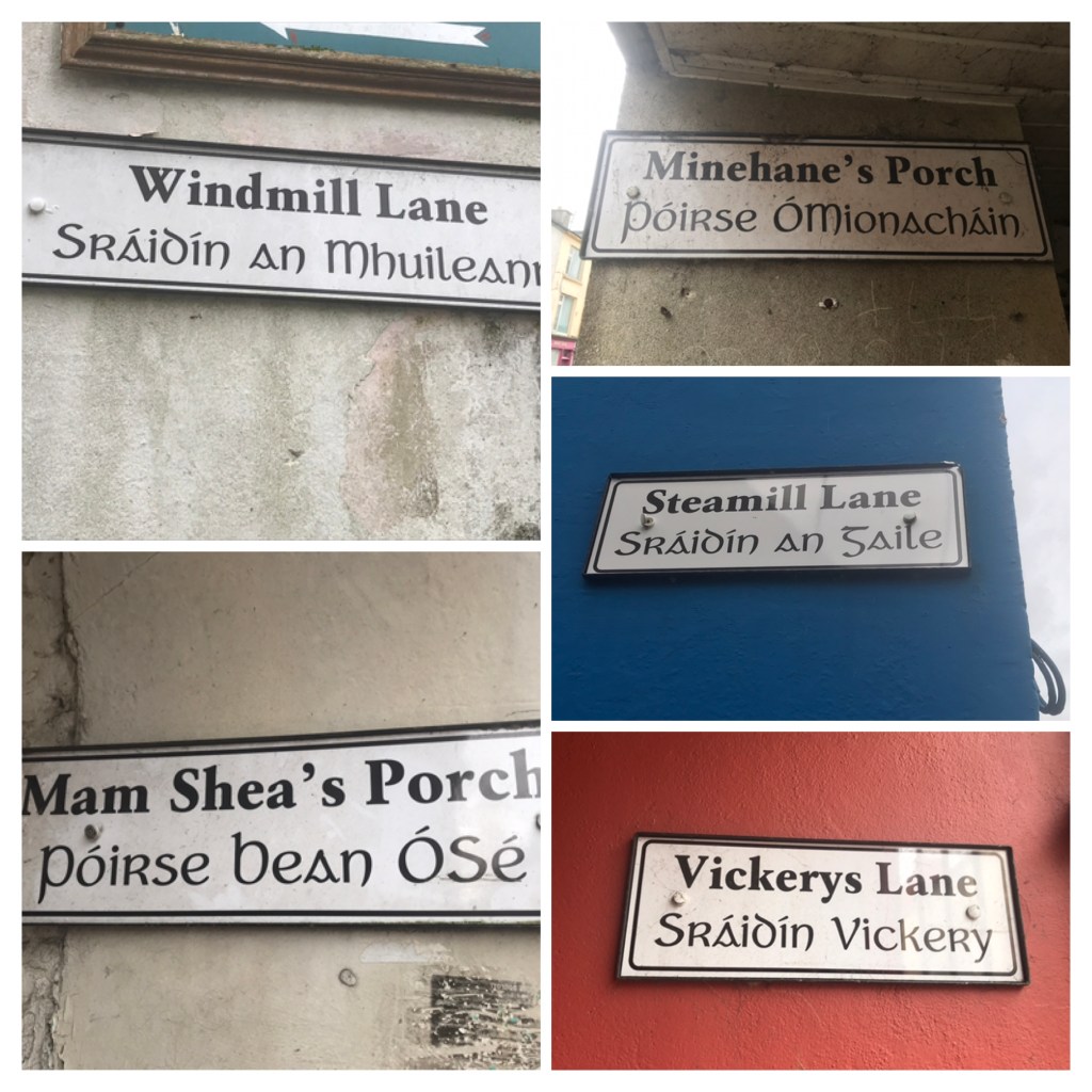
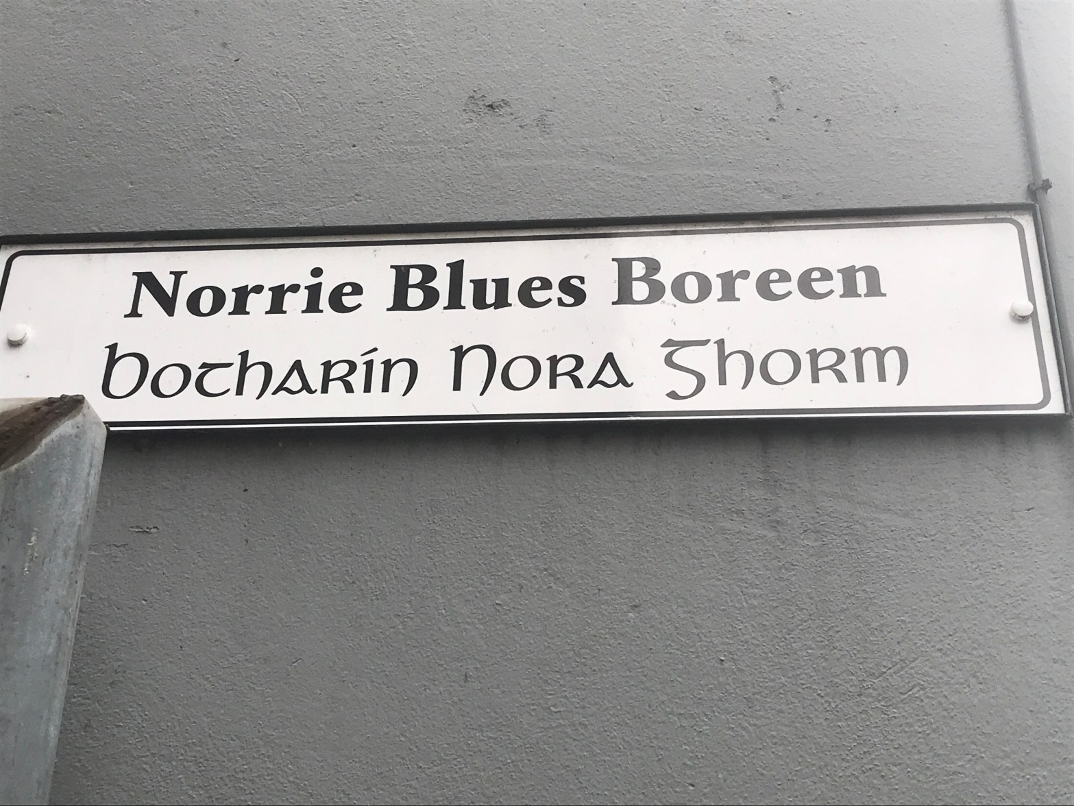
We loved the network of wonderful lanes and ‘porches’ that link the main streets of your town and we commend you on the signage which highlights their eye-catching names like Brewery Porch, Windmill Lane and Norrie Blues Boreen. Has any consideration been given to providing storyboards on how these names came about? These are a wonderfully distinctive feature of your town and they could be very effective in promoting walking and cycling as they greatly improve permeability.
Adjudicator Report, 2018
And so we set about locating the history behind these place names, some of which we share in this blog post. The process took some time but as the saying goes ‘all good things are worth the wait’. Four people were central to this effort and deserve special thanks. Adrian Healy came up trumps with a wonderful manila folder of the oral history of these place names provided by local historians, Gerald O’Brien and the late Patrick Cleary (R.I.P.). More recently, Helen Casey typed up the handwritten notes that form the basis for this post.
When you next walk the streets of Skibbereen do keep an eye out for some of these lanes and porches, and reflect on what times were like for our ancestors who walked them so long ago and in whose steps we follow every day.
| Map* | Place name | Origins and comments courtesy of Gerald O’Brien and Adrian Healy |
| A | Chapel Quay | See note** |
| B | Steam Mill Quay | See note** |
| C | Levis’ Quay | Levis’ Quay was called Main Street Quay on the Griffith Survey Map (1853) – but O’Sullivans old shop had the name Levis’ Quay on it. The 1901 OS map also uses the name Levis. |
| D | Coppinger’s Lane | According to Griffith (1853), Margaret Coppinger was the immediate lessor of all the houses in both lanes. She was also the immediate lessor of 19 houses in Mardyke. |
| E1 | Clerke’s Lane (Townshend Street) | Clerke’s Lane (Townshend Street) bore the name in the Townshend estate map of 1897. |
| E2 | Clerke’s Lane (Main Street) | Clerke’s Lane (Main Street) bore this name in the Griffith Valuation of 1853. Lane E1 and E2 were, it would seem, linked by a bridge over the Caol stream. |
| F | Tanyard Porch | This porch linked the Tanyard to the street, Pigot’s directory of 1824, named Charles Gay as a Tanner of Main Street. John Levis, it would seem, took over the Tanyard and when the Griffith Surveyors came to town there were twenty five tan holes on the premises. |
| G | Brewery Porch | Confusion reigns, however, it appears the owners of the brewery were the McCarthys of Lough Ine and later Glencurragh (from the early 1850s). The product was called McCarthy’s Porter. The managers of the day-to-day affairs in the brewery were the McCarthy family. |
| H | Table Lane | Table Lane is named on the Griffith Survey Map (1853). The (original) laneway was demolished when Market Street was developed in the 1850s. The name is of importance as it keeps alive the market square link of the 19th and 20th century when the street traders retrieved their tables from Table Lane and set up their stalls in the Square on market days. |
| J | Distillery Lane | Like many towns of the 18th and 19th centuries, Skibbereen had its own distillery. Two contributors to the convent building fund gave their addresses as Distillery Lane, while baptismal records in Prospect House show several registrations to this lane. |
| K | Warner’s Lane | This lane was developed by a Mr Warner in the late 1800s. |
| L | Norrie Blues Boreen | Older residents of Skibbereen use this name or the related Norrie Blues Lane. |
| M | Gasworks Porch | Skibbereen’s first public lighting system, gas lights, were first ‘switched on’ on 15 August, 1868. |
| N | Bóthar Daoimhín | Older residents of Skibbereen have been heard to refer to this name for the steep, non-vehicular walkway connecting North Street to Windmill Hill. |
| O | Bridgetown Quay | Details to follow. |
| P | Old Bridge Street | This street or lane bears no name but is regarded by many as the original Bridge Street – it is now mainly used to access the car parks of the West Cork and Eldon Hotels. |
| R | Temperance Place / McCaura Place | The entrance to the car park from Townshend Street passes over part of the site of the old Temperance hall and is also near the birth place of Gerald McCaura. |
| S | Osiery Place | The entrance to the car park from Market Street and part of the properties of Drinagh Co-op and Barry Bros. was occupied by an Osiery in the 19th century. |
| T | Aghaclare Lane | This lane appears in the papers of part of the McCarthy Downing estate. |
| U | Convent Hill | Has been known as Convent Hill probably since the foundation of the convent in the 19th century. |
| V | De La Salle Road | The relatively new roadway leading to Skibbereen Sports and Fitness Centre, along with a number of education institutions, is closely associated with the De La Salle brothers, who donated the lower part of the road for subsequent development as we know the area today. |
* Please note that the map of these locations is not currently digitised.
**The names of places A through G have overwhelming evidence of origin, both from written records and oral tradition.
We hope you have enjoyed reading this post, a contributing step towards recording the important heritage of these place names. A walk around town indicates that this work is far from complete and the photo collage might prompt some memories.
If you or your family members have any further information that will help us continue this important record please contact Sandra at SkibbereenTidyTowns@iCloud.com.